Two Hard-Hitting Hurricane Seasons
Last year was a September to remember in the US as far as hurricanes go. First, Harvey hit Texas with 130-mph winds and thundering rains totaling up to 60 inches in places, setting all-time US rainfall records. Next, Irma created havoc across the Caribbean and Florida as the strongest Atlantic hurricane on record, with 185-mph sustained winds that leveled islands and nearly created a nightmare scenario in Florida. And of course no one will forget Maria, which hit an ill-prepared Puerto Rico with catastrophic results.
Here are some recent pieces in which I describe the effects of these hurricanes:
https://www.cumber.com/key-west-bob-bunting/
http://bobsstocks.com/cuba-caribbean-hurricanes-now/
https://www.sarasotamagazine.com/slideshows/2018/7/1/how-cuba-saved-florida-from-a-category-5-hurricane
From June through August the 2018 hurricane season yielded a slightly elevated number of storms, but all were weak. Elevated wind shear, a near-record cold Atlantic Ocean, and Sahara dust clouds combined to lull us to sleep – that is, until Florence formed in September off the African coast, just as Irma had. This time the track was more northwest, across thousands of miles of open water. Finally, Florence hit a patch of warm water, found low wind shear, and fought off the dust. The result was the first major hurricane of 2018 and one that had a clear shot at the Carolina coast.
Packing 140-mph winds after a 24-hour cycle of super-rapid intensification, Florence was not a storm to discount. The Carolinas are a magnet for Atlantic hurricanes: Think Hazel, Hugo, Gloria, and Donna, among others. But what made Florence even more of a threat was both human denial and the natural slope of the continental shelf, which is shallow and thus amplifies storm surge, especially for storms coming into the coast at right angles. Usually storms approach from the south, not from the east. It makes a difference. Florence came in perpendicular to the coast and acted much like a plow pushing the water at the coast, creating a large storm surge even as the storm itself weakened, striking with top winds of 106 mph.
Like Harvey, this massive storm ground to a halt just as it was making landfall. As with Harvey, record rains pelted North and South Carolina for days, dumping trillions of gallons of water on ground already saturated from a very wet summer. With storm surge and 30+ inches of record-setting rainfall, epic flooding resulted. Many rivers crested at levels that are hit only in a 1000-year flood, inflicting widespread major flooding that continued for weeks and killed not only people but millions of animals, creating billions in losses.
Finally, it was October 2018, and many began to think we were done with hurricanes. After all, at this point, although there had been many weak tropical storms and hurricanes, there had been only one major storm, and now Florence was out of the news.
Back in June, the Sarasota magazine published a nice summary of hurricanes, and I was pleased to be part of the spread of articles. Here is an excerpt from the discussion of Sarasota and hurricanes:
“Sarasota is more vulnerable to storms – like Wilma or Charley – that form in the Caribbean and enter the Gulf of Mexico, usually early or late in hurricane season. (The most perilous time for us, Bunting says, is the first two weeks of October.) But even those storms rarely hit our stretch of the west coast. Because of the shape of Florida’s land mass and atmospheric factors related to the rotation of the earth, they tend instead to make landfall to the south, often around Naples, and travel east across Florida, or to curve north and hit the northern Gulf Coast.
“Does this mean we can breathe easy? Hardly, says Bunting, who confesses, ‘I couldn’t sleep’ during the days that Irma threatened our coast. ‘All it takes is one,’ he says. ‘Only one.’”
You can read the entire article(s) here: https://www.sarasotamagazine.com/articles/2018/6/27/major-hurricanes-rarely-hit-our-region-here-s-why
Sure enough, in the second week of October a weak tropical system emerged south of Cuba, in the area climatologically favorable for late-season hurricane formation. This worrying development was made even more scary by a very warm loop current in the Gulf of Mexico, which was moving warmer than normal sea-surface temperatures off the West Florida Centennial Shelf northward to a position near the Big Bend region of Florida. Tropical Storm Michael entered the Gulf, and as it moved almost due north, it began to strengthen.
At first a Category 1 hurricane, Michael soon sucked energy from the warm loop current and intensified with a bang! During the next 24 hours the storm churned northwest of Sarasota toward Mexico Beach in northwest Florida. The Category 1 storm exploded to a very strong Category 4 with 155-mph winds; and the eye wall, surrounding a pinpoint eye, struck Mexico Beach and surroundings like a large tornado, complete with a storm surge. Wiping the Earth’s surface clean at the impact point, Michael registered the third lowest pressure ever recorded in the eye of a US hurricane making landfall – 919 mb. Imagine the panic of people watching the radar images like the one below as the storm approached the beach.
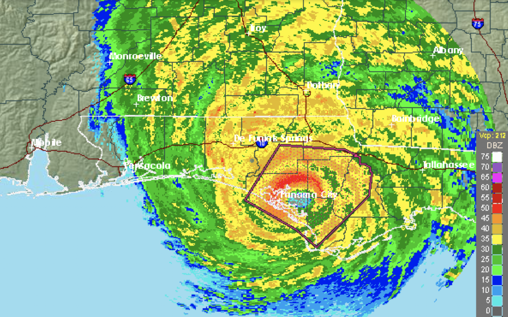
Note, too, the small eye surrounded by the red eye wall as Michael ravaged the town of Mexico Beach. As the hours passed, much of northwest Florida and parts of Georgia saw record wind speeds and mass destruction totaling billions.
Is Climate Change Responsible?
Are hurricanes getting stronger because of climate warming? Are nature’s largest storm events and the rainfall totals they bring being magnified by the climate change? Is humanity responding to the threats or simply ignoring reality in hopes that the threats will go away or that our descendants will mitigate them later? Does sea level rise play a role in what appears, to the uninitiated, to be worsening storm impacts? Are we still dealing with critics who say that what we are seeing is nothing unusual or that everything can be blamed on a warming climate?
Let’s answer these questions to the extent that they can be answered. While 2017–18 featured the strongest set of hurricanes ever recorded, there isn’t enough evidence yet to say that hurricanes are stronger now than they have been in the past. This year, including Florence and Michael, has been above normal with regard to the number of storms (15) but normal with respect to the number of major hurricanes (2). Those two storms happened to hit the Mid-Atlantic Coast and Gulf Coast. It just takes one such event to change perceptions, and we had two.
But it is accurate to say that for each degree the air warms, it can hold nearly 4% more water. It is also accurate to say that warmer ocean waters have more heat potential, thereby increasing storm intensity, all other things being equal. So while the recent record of hurricanes does not prove in a statistical sense that hurricanes are more intense because of a rapidly warming climate, there is room for legitimate concern.
Explosive storm development also seems to be different and more concerning than in the past. Harvey, Irma, Florence, and Michael all had 24-hour periods during which they exploded from Category 1 to Category 4 or 5! Warmer sea-surface temperatures are clearly one major factor. In heavily populated areas, if such explosive storm development occurs, evacuation just cannot happen in time. How to deal with this issue will be one of the most talked-about topics for years to come as we learn how to adapt to climate-warming issues.
There is also evidence that heavier rain events are being caused in some part by the warming climate. First, as noted above, warmer air can hold more moisture; but also, as the earth warms, the jet streams tend to set up further north and are weaker than was normal for most of the 20th century. These two factors mean that storms hold more rain and tend to slow down and meander rather than moving at a brisk clip with the help of jet stream winds. Harvey and Florence certainly did just that, and I agree with the IPCC conclusion that slower-moving storms with heavier precipitation are becoming more common.
What, if anything, are we doing about these trends? Certainly, an effort is occurring in the US and other countries to limit greenhouse gases, with or without the Paris Agreement, and much more is needed in both the short and long term. But with regard to hurricanes in North Carolina, there has been little action to protect the eroding shoreline. A recent news article tells the story:
https://www.huffingtonpost.com/entry/north-carolina-sea-level-rise-hurricane-florence_us_5b985a87e4b0162f4731da0e
In Florida, local communities are getting more involved in protecting themselves, but still there is still too little happening on state and regional levels.
Sea level is now rising about an inch every seven to eight years now. Along the North Carolina coast the sea level has risen about 6.5 inches since 1950. When storm surges occur on top of even a modest sea level rise and the continental shelf is shallow, the surge/flood impacts from both major and minor hurricanes are amplified. This was the case with Category 2 Florence!
An interesting point and counterpoint were recently raised in California regarding climate warming, at the Climate Action Summit (https://www.globalclimateactionsummit.org) in San Francisco, which featured many impressive and interesting presentations.
One troubling takeaway was the emphasis on attributing every bad weather event, from droughts to fires and floods, to climate warming. Fires, floods, and droughts have been around for a very long time. The key point, however, is that our climate is warming much faster now than climatic changes have unfolded in the past. Changes that used to take thousands of years are being compressed into decades. This precipitous rate of change is what is so troubling!
The counterpoint was a series of panel discussions organized by a group called the Hartland Foundation, specifically to rebut the Climate Action Summit and climate warming in general. See https://youtu.be/5_XSrrw4DDc.
This group was less impressive and seemed to focus more on PR than scientific discussion. I was struck by the dearth of IPCC members or representation from first-rate science institutions at this gathering. This group failed to identify the rate of climate warming as unusual and highly correlated to human-generated greenhouse gas emissions.
Ignoring what is and hoping for the best is not a strategy. Shooting the messenger , climate science, is costing us big-time, but perhaps the lessons from Florence will lead to a more reasoned and action-oriented approach. As many readers know, I am not in the camp that expects worst-case scenarios of sea level rise by 2100. See my article
https://www.cumber.com/guest-commentary-by-bob-bunting-its-getting-hotter/.
But there is no reason to believe that the past and current trend of sea level rise will suddenly stop and good reason to believe, on the other hand, that the rate will increase as global temperatures continue to rise.
Evidence Calls for Action
While fair debate is welcome and needed, dismissing climate warming as nonexistent is not helpful, nor is sensationally predicting the end of the world by 2100. What is helpful is concerted action to mitigate the impacts of the most likely climate-warming scenarios. Preventing further damage to the climate by limiting greenhouse emissions, pushing technological solutions, and promoting scientific understanding are key to being successful – as I know we can be!
Policy reacts to the will of society but with a time lag. That’s why it’s so important to study this issue and not be drawn in by polarizing positions. It is all too easy to jump on bandwagons, but the answers are now largely known for those who want to deal with high-probability scenarios. In North Carolina an opportunity was missed on a statewide level. During the 1990s, as I discussed in my previous article published by Cumberland, the US and the world missed an early opportunity to deal with climate warming. Now it’s time for local action that will trickle up rather than down. Perhaps North Carolina and its coastal communities will help lead the way.
Florida is one of most vulnerable areas, with $7T in real estate along the beach lying in harm’s way and with climate-enhanced red tide becoming more of a real problem. Florida has the opportunity to lead the climate adaptation movement for local and regional mitigation of the additional climate changes sure to come in the next decades.
Herein lies a series of opportunities for local and regional coordination through a new center in the Sarasota-Manatee area that can take developing climate science and tailor it for decision makers in state, regional, and local governments. Billions of dollars already being spent can be better utilized for the formation of effective, coordinated, and enduring adaptive solutions.
Also, because the adaptation to climate warming is one of the most important issues of our time, the situation is ripe for entrepreneurs who want to stop talking and start doing! I predict that new business development in this area will create an economic boom for those who can seize the opportunity!
Sarasota -Manatee is ground zero for climate impacts from rising sea levels, explosive hurricane development, and red tide. Because it is, it can be a hub that helps Florida, the region, and local levels to create a platform for academia, government, and the private sector to foster mitigation and adaptation as well as to catalyze economic opportunities that mitigation will surely spark.
Florida and the Sarasota-Manatee area have the expertise, financial resources, and leadership to help broker a more effective approach to dealing with climate-change impacts. It’s time to take the abundant resources we have available and organize them, much as Steve Jobs and company did when they reinvented the phone with the iPhone. They took the pieces that we all use in our daily lives, from music to calendars and from news to maps, and handed them back to us in the form of an “on the go” platform that integrated what already existed into a truly transformative device. That example provides the inspiration that we can do it, too; but this time we are challenged to creatively adapt to deal with an issue that will fundamentally impact all our lives. Stay tuned!
We thank Bob for allowing us to publish his work: Bob Bunting – atmospheric scientist, author, educator, and entrepreneur.
Links to other websites or electronic media controlled or offered by Third-Parties (non-affiliates of Cumberland Advisors) are provided only as a reference and courtesy to our users. Cumberland Advisors has no control over such websites, does not recommend or endorse any opinions, ideas, products, information, or content of such sites, and makes no warranties as to the accuracy, completeness, reliability or suitability of their content. Cumberland Advisors hereby disclaims liability for any information, materials, products or services posted or offered at any of the Third-Party websites. The Third-Party may have a privacy and/or security policy different from that of Cumberland Advisors. Therefore, please refer to the specific privacy and security policies of the Third-Party when accessing their websites.
Sign up for our FREE Cumberland Market Commentaries
Cumberland Advisors Market Commentaries offer insights and analysis on upcoming, important economic issues that potentially impact global financial markets. Our team shares their thinking on global economic developments, market news and other factors that often influence investment opportunities and strategies.